Floats on Glass!
At the terminus of many glaciers, meltwater fills massive lakes ground-out by the immeasurable weight of the former tongue of advancing glacial ice. They are only temporary, in the larger scheme of things, but allow for cautious access to experience the true exposure of raw land after untold millennia under ice. These lakes are very turbid because they are filled with glacier silt and visibility as to where rocks may lie just below the surface is non-existent, making for dangerous conditions until depth soundings are taken.
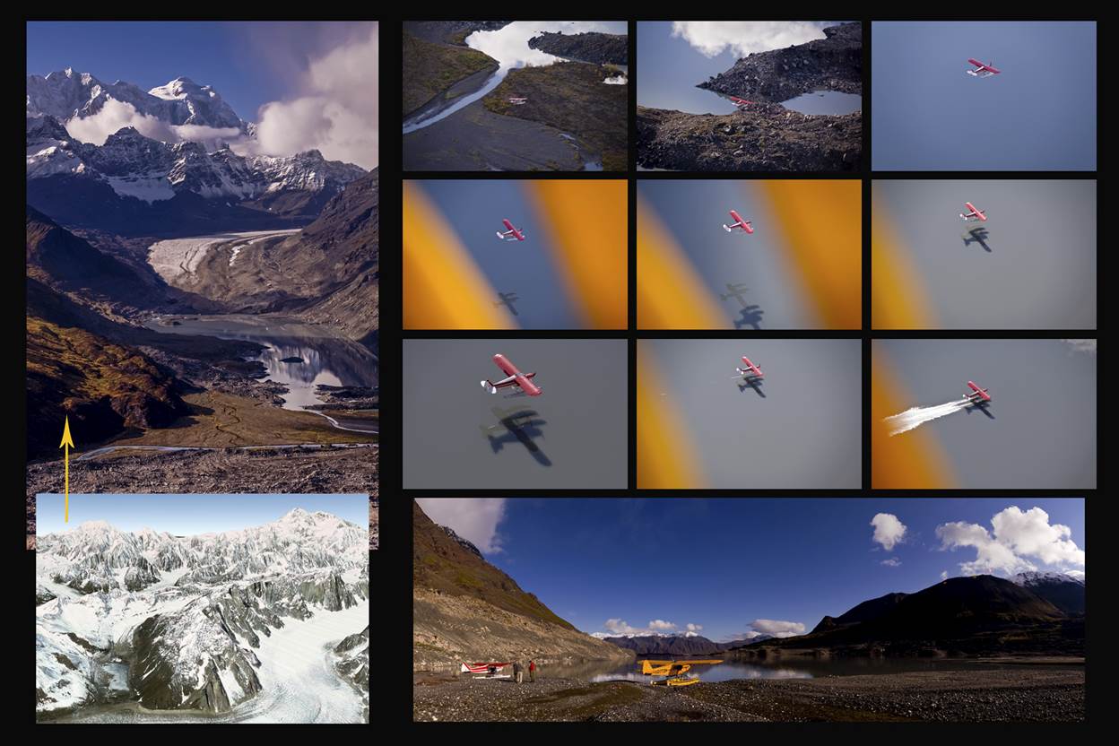
Such is the “Backside Glacier,” first referred to and named by renowned mountain climber Dave Johnston in 1975 as a route to access the "backside" of the massive granite spires of the Great Gorge of the Ruth Glacier. Veteran helicopter and bush pilot Jim Okonek made his very first glacier-landing there while bringing in a climbing party around that same year. The terminus lake, now locally called “Backside Lake,” was still being formed under ice and rock, just shy of a half-century ago.
Above at left, the Google image points out the area from which the aerial image above it was taken of Backside Lake with Mt. Hunter in the background. The series of Jim’s Super Cub landing begins at top left with the rapid drop to line up on approach, which can be located in the larger image where the river exits the lake. Jim later explained that this is one of the more difficult types of float plane landings for the simple reason there is no perception of the water’s surface. Without wind, cloud reflections, or ripples, it becomes a featureless blue mirror and a pilot must take extra care by running a long slow line for a glassy water-landing.
This series shows the long-skilled approach with the mirrored reflection, and then the actual shadow of the Cub stacking together as the floats finally make contact the surface. In the panorama above, the true size and grandeur of Backside Lake and the huge valley the glacier had carved out becomes very apparent. The light-colored rock up the cliffs to the left of the planes shows a "moraine lip" where the height of the glacier once existed, which is also very visible in the aerial image at the left. To have experienced this amazing part of the Alaska Range, even for only a half hour on the terminus shoreline, was a gift to treasure for a lifetime.
All images © Dave Parkhurst www.TheAlaskaCollection.com


